Cloud Forest Diary

Back to Monteverde

Back to Costa Rica Itinerary

Absence of real rain, even with a moist and swampy feeling can only be observed in a cloud forest. While rain forests are common, cloud forests are not simply because of the requirement of a certain altitude and formation of clouds through rainshadow regions. There are a few privately owned and maintained parks in Monteverde, that encapsulates the extreme biodiversity along with the geographical intricacies.

The Santa Elena Cloud Forest Reserve and Monteverde Cloud Forest Reserve are two prime parks in the area where you can experience the diverse species of animals and vegetation. We explored the two parks starting early morning when the opportunity to see some of the more elusive animals are more. Most efficient and effective way of seeing the parks are with guides simply because of their experience of spotting camouflaged animals. In most cases, the trails are well maintained and directed.

Monteverde Cloud Forest Reserve

Address: Monteverde Cloud Forest Reserve 55-5655, Costa Rica

This is one of the oldest reserves and has quite a few trails around the park. Without guide but with a slow walking pace keeping eyes and ears open for cues, it took us 5 hours mostly because of the sudden elevation gains. We took the Cloud Forest Trail, El Camino, Swamp Trail along the continental divide, Shining Trail that leads to La Ventana with an overlook to both sides of the divide (you can easily tell the difference between the two sides of the rainshadow region from here), and Suspended Bridge with a spectacular view of the canopy and some more wildlife.

Santa Elena Cloud Forest Reserve

Address: 6 km (4 mi) north of Santa Elena, Costa Rica (+506 2645 5390)

This park requires reservations and a shuttle ($2 per person) picks up visitors from their hotels. Located north of the town, next to the Selvatura Adventure Park, it has a couple of easy trails (e.g. Cano Negro). In the easy paced trail, there are a few lookouts to the Arenal Volcano, but visibility is often going to hinder any views. A nice quiet park to enjoy the tranquility but for the admission fee of $14 per person, and with other options available, we thought this park can easily be skipped.

Night walk in the Monteverde Cloud Forest Reserve

Probably one of our best experiences in spending time in the forests, to book a night walk trip in the Monteverde Cloud Forest. We booked through Anywhere Costa Rica. Priced at $50 per person, they pick you up from the hotel before dark and drive up to the entrance of the park. A scary gondola ride through the dense fog as darkness sets in, is followed by a walk around the park through the suspension bridges trying to spot nocturnal animals. We spotted several nocturnal frogs, a tarantula, owls and birds. But we heard that on other days you can spot many more creatures albeit with flashlights.

Curi Cancha Reserve

Address: 300 meters west of the Monteverde Cheese Factory, 60109, Costa Rica

Not one of the most advertised places, therefore sort of off-the-beaten-path, the Curi Cancha reserve is located near the Monteverde Cloud F0rest Reserve and is also a privately owned park. They have knowledgeable local guides and photographers who can guide you through the park and a large network of them make it easier to spot elusive species of mammals, birds and reptiles. We found this to be the most underrated parks to spot wildlife in Monteverde. Takes about 3 hours to complete but again to maximize your chances of spotting wildlife, go as early as possible.


The Canyons – Grand Circle Trip

In a journey to unknowns, through barely traveled roads, with only a dream in mind, and the best friend for company, we set out to look at mother Earth at its best – the spectacular canyons of the American south-west. In this journey through historic crossroads and beautiful formations, we drove more than 3,500 miles for 8 days with Tom Petty and Pink Floyd-on repeat.

fa5bf-summary

Montage of our cross-country travels

In the drive through 9 states, hikes up the mesas, drive in river gorges, unpaved country roads, we met some amazing people, tasted aboriginal cuisine and pinned memories for a lifetime. We started this 3,500 mile trip from Austin, TX and ended in Indiana crossing TX, NM, AZ, UT, CO, KS, MO, IL, and IN.

The Canyons and POIs covered – Albuquerque, NM, Monument Valley, Zion National Park, Bryce Canyon, Capitol Reef, Arches National Park, Canyonlands National Park.

Itinerary and Travelogue

Day 1 | Austin, TX to Clovis, NM | 500 Miles

We loaded up the trunk of the sedan, and bid adieu to Austin which was my home for the summer, 2012. Apprehensive about how the car would endure the 3500 mile long drive, we set out for the greatest adventure of our lives so far. Loaded with caffeine, we charged for about 500 miles on the first day, taking advantage of the close-to-zero traffic and great weather. In an apparently uneventful day, we managed to enter New Mexico, and stopped for a night in a small motel in the little town of Clovis, NM. Had Mexican food for dinner, and called it a day pretty early.

Day 2 | Clovis, NM – Albuquerque, NM – Aztec Ruins – Farmington, NM | 540 Miles

On the Saturday morning, loaded with continental breakfast, and coffee (well, could not spot a Starbucks around), the drive to Albuquerque, NM began. We reached the town around noon, and found a nice place for lunch on the historic Route 66. We knew that the

29059-kimotheater

KiMo Theater (Albuquerque)

Route 66 would be with us for a major period of the drive, but this was probably the only spot en route, that had any touristy value. Route 66 was laid in 1926, and ran from Chicago, IL to Santa Monica, CA through MO, KS, OK, TX, NM, and AZ, a 2300 mile long endeavor. The city of Albuquerque, NM, though a historic city, did not have a vibe about it. Rusty buildings, and lower than expected pedestrians on the main street was disappointing. Apart from the historic (and often referred to as ghostly) KiMo Theater, the downtown did not have much to offer.

So, we decided to focus on the later part of the day, which was to check out other national parks along the way. We did some research on the go, and decided to swing by the Aztec ruins in Aztec, NM. We reached towards the end of the day’s hours, but managed to take a close look at the ruins in the park. There was a self-guided tour available, and all you had to do was to walk along the designated trail. Intriguing aspects of Aztecs’ lives were

a9afe-219427_4511021212033_2067413213_o

Aztec Ruins, NM

depicted in the rooms that were built thousands of years ago. Skillful stone masonry, wood roofing, and other architectural structures apart, the great Kiva, the subterranean structure that housed major events in Aztecs’ lives, were literally enlightening. Further details about the Aztec Ruins National Park can be found here. It is a must visit for anyone interested in the history of the native civilizations of the area.
At the end of a busy traveling day, we decided to stop at the nearest small-town of Farmington, NM. An early start of the next day was looming!

Day 3 | Farmington, NM – Four Corners – Monument Valley – Kanab, UT | 300 Miles

Poetic literature often associates beauty with greenery, ice-capped mountains, or serene water bodies. But our rendezvous with some of the most barren lands in the area rendered those definitions of natural beauty, incomplete. On our way to the Monument Valley, UT, from the Travelodge in Farmington, we encountered numerous Mesas and Buttes in the Colorado plateau. With elevation slowly increasing, the human habitations were becoming scarce with every mile traveled.
As we entered the Navajo habitats, we came close to a distinct point of interest: The four corners monument. A part of the Navajo Nation parks, the area is very remote, but once you get there, it is a serene environment with nothing other than square miles of open barren land surrounding it. It is the only place in the USA where four states Utah, New Mexico, Arizona, and Colorado meet. Spend a few minutes with the local Navajo artisans to check out their handmade jewelry, crafts, and traditional food. Nothing extravagant on display, but if you must, it is better to buy from these places compared to larger visitor parks so that the money goes to their families.

The next 100 odd miles approaching Monument valley from south, through highway 163 was like a John Denver song playing in repeat mode; Mesas, serene valleys, and country roads. Remember the scene from Forrest Gump where he runs across the country through these very roads with Monument Valley in the background? The entire stretch of highway monument-valley163 approaching or leaving the park, it is a vista you’d fail to erase from memories. After multiple stops to capture the panorama, we entered theMonument Valley national park, also a part of the Navajo nation parks and recreation areas. Further details about Monument Valley can be found here.

Our aim was to put icing on the cake by setting foot in the charismatic Antelope Canyon in AZ by the end of the day. But alas, not everything may go as planned, since the weather Gods intervened with a heavy downpour that flooded the canyon bed. We were disappointed to reach the canyon through Page, AZ, yet it was something that we did not mind paying another visit, another time.

Rather than wasting precious time, we headed for the Horseshoe Bend. It is conveniently located on Rt 89 (although I hear that a landslide in early 2013 closed that approach road). An extremely tiring hike taking close to 90 minutes, one-way, was unplanned, but

Trip Details - Grand Circle Canyons

Horseshoe Bend (Page, AZ)

rewarding. The sand on the hike path may seem like a nuisance, but it is a walk through history. From pre-historic times, the biggest sand dune in the region went through a lot of weathering, resulting in sand stone layers known as ‘ergs‘. As seen in the photo here, it is a fantastic view to witness a vertical drop of a whooping 980 meters, and a 270 degree turn by the Colorado river. You need a wide angle lens to capture the entire canyon bend in the picture. The iOS panorama mode does the job too! But the mighty Colorado river has eroded through the sandstone from millions of years to get to this natural bend, and may be in the near future (in geologic time scale), we might witness a natural bridge where the river abandons the circular bend altogether.

Anyway, after a thousand pictures and dipping in the serenity of the spectacular Horseshoe Bend, our tired, dehydrated souls sought the comfort of a bed and warmth of dripping hot water from the shower. So we started driving, again, to search for our hotel in Kanab, UT, Shilo Inn and Suites, a less than standard hotel in the small Mormon town. In spite of being a relatively famous town for the shots in a number of Hollywood movies, the town remains closed for businesses on Sundays(!). We managed to not find a decent place for dinner, and found it hard to locate even a gas station that was open on Sunday. Who knew?

Day 4 | Kanab, UT – Zion National Park – Bryce Canyon – Moab, UT | 300 Miles

Monday morning threw no jitters as we left the town right at dawn to hit the curves and tunnels en route to Zion National Park. We had half a day, so went straight at it after

whizzing past the entrance using our NPS card. Through the visitor center, we walked and hiked through the mesmerizing landscapes of this huge national park. We walked through rivers with ankle high water, hiked to top of the canyons, drenched in emerald pools and sipped the beauty of the flora and fauna around barren yet beautiful landscape. Our favorite POIs were the lower and upper falls, emerald pools, checkerboard mesa, the narrows, and the main canyon. Honestly, one can spend 2-3 days easily and hiking every day all day, yet to cover all the spots. Half a day was crazily below average time people spend here. Nevertheless, we will cover the geology and the environmental tales of Zion in a separate post.

For now lets focus on the next spot – Bryce Canyons. We had a little bit of lunch and headed to Bryce Canyons National Park, a mere 50 minutes drive. But boy, what a drive it was. Surrounded by a landscape that drastically changed every 15 minutes. We went from green river valley to rocky cliffs to barren country side in a matter of minutes. Until we crossed the famous natural ‘bridge’, we had a feeling we are lost and going in the wrong direction. After entering the park, it seemed to be a different world, at least compared to Zion where we were just less than an hour ago.

bryce2

Vivid colors of the Hoodoo’s

From the visitor center to all the POIs, it seemed extremely touristy and the paths are all paved. Not many wilderness trails exist probably for obvious reasons – that the landscape is dangerous with steep cliffs and nothing to hold on to, and sharp drops to the bottom of the canyons. The highlight of this park has to be the ‘hoodoos’ which are best viewed at sunset. The red and orange hues come out swinging at the dying lights of the day. The gorgeous structures are actually formed by wind corrosion and not water weathering. The Bryce Canyon is not really a canyon, but a inverse dome where the bottom layer of rock is weaker than the top layer. Therefore with time, the bottom layer gets corroded faster than the top layer, and creates these fanciful ‘hoodoos’.

There is a steep and slippery pathway to go to the floor of the ‘canyon’ or dome to be with the hoodoos. It is a tough climb back but definitely a must since at various levels, the photo-ops and the panorama changes vividly. Even though it has a lot to offer, one day here should be enough for a savvy hiker to complete.

After a tiring day, we headed towards Torrey, UT which is close to our next stop – Capitol Reef National Park.

Day 5 | Torrey, UT – Capitol Reef – Arches National Park – Moab, UT | 150 Miles

Not a single park in our agenda deserves a half day, but still we pushed on for two more natural wonders. First on the list – Capitol Reef National Park. Possibly the largest of all the parks we covered in this trip, the name of the park comes from the famous whitish domes that resemble the US Capitol building. The primary attraction here is the Waterpocket fold which is a faultline in geologic terms representing a collision of two plates 70-80 million years ago. The structures that we see and feel awestruck were formed due to million years’ of weathering. Viewing the faultline from the scenic overlook is a fascinating experience.

Another interesting experience while in this park was to drive into a river gorge, infamous

capitol-reef-gorge2

River gorge, Capitol Reef

for flash floods upon sudden downpours. While it requires a 4×4, we went in with a sedan and parked at a safe distance before venturing on foot to the gorge. As seen in the picture here, I used Rupsa as a scale to show the enormity of the gorge. Imagine a river flowing through this slot canyon! Humbling indeed that we appear so small when compared to the wonders of nature.

Talking about humans, we found traces of petryglyphs (symbols and letters imprinted on

capitol-reef-petryglyphs

Petroglyphs at Capitol Reef

rocks), in various parts of the park signifying the presence of ancient aztecs and their villages. There are a number of hiking trails that take you to the arches, canyons and overlook trails for impressive photo ops and bit of exercise.

After about 5-6 hours in the park, we headed out to Arches National Park near Moab, UT. Just about 100 miles away, it awaited another surprise for us. A park full of arch like structures with the center eroded making it see through! Natural wonders are like McDonalds in this area, only that the flavors and taste differ so significantly. We drove through the park first just to scale the area and to prioritize our hikes. This is a popular park and a lot of visitors actually stay overnight camping. We heard that the starry nights are fascinating because of the lack of air and light pollution.

There are tens and thousands of arches of various kinds here. The popular and our favorite ones are – delicate arch, double arch, window/ventana arch, and turret arch. The geology behind the formation of the arches is intriguing. Million years ago, this land was under the sea indicated by the discovery of fossils of oceanic creatures, mollusks, shells. Once the seas receded, the large basin covered with thick salt beds was covered in turn with large rocks carried in by the streams and rivers. The salt levels being lighter, pushes up the rock layer to create higher rock formations from the valleys. After groundwater dissolved the salt layer, the top layer collapsed into wall like structures. After 100-150 million years’ of weathering, these tall wall like structures took shape of these arches which are made of soft red sandstone. These arches are not permanent structures; new arches are being formed every day while old ones collapse.

The hike to the Delicate arch is a strenuous one, but extremely rewarding. The other arches have their own charm with various structural intricacies, and variation of grandeur. One can easily spend a week here just soaking in the charm of the delicate natural wonders.

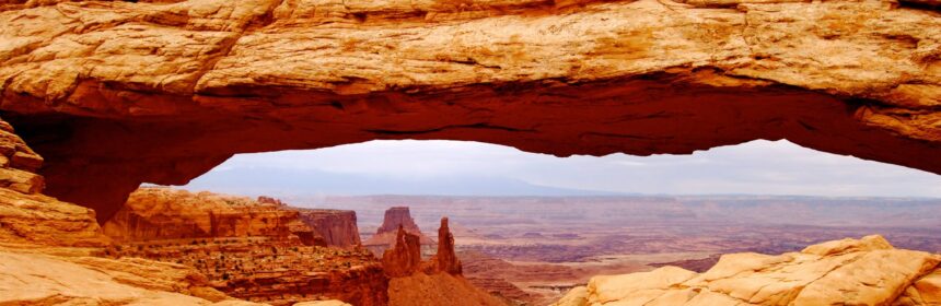
Day 6 | Moab, UT – Canyonlands National Park – Denver, CO | 150 Miles

Running from one national park to the other would tire you out right? Nope. If you are in good physical shape, the sheer variety of the natural wonders and their splendor would be able to keep you going. An overnight stay in the quaint town of Moab, UT, we ventured out to the last one in our list – Canyonlands National Park.

This one is a humongous park with three different sections – Island in the sky, The Maze and The Needles. The Maze and Needles are not accessible from the Island in the sky. Our POI was Island in the Sky and the primary spots – Green River Outlook, Upheaval Dome and Grand View. From the Green River outlook, we could see the entire river valley with the canyons and the bends of the river.

Geologically, the two mighty rivers – Green River and Colorado River flowing together in the park has created the three segments and the entire landscape of this area. There are not many paved roads for normal cars but if you have a 4×4, lot of off-roads are available to explore the canyon and the river banks.

After spending about 5-6 hours in the park, we headed out to the mid-west, Denver being the first stop.

A shame that we had to cover all these splendid parks in only a week, but to our credit we stayed fit and finished strong. We are going to hit these parks again for slightly longer time at a later time. Hope to update this travelogue with a lot more scientific and picturesque logs at that time.


Lua’u and a brief history of Hawaii

It is a must do for any first time traveler to the Hawaiian islands. The Old Lahaina Luau, in Maui, possibly had the best experience for us that it combined the hula dance show with a focus on the cultural and mythological perspective while devouring on delicious traditional dishes. Read more details on the food and our experience in my Tripadvisor review.

Let’s talk about the show and some perspectives on Hawaiian history –

What is Luau?

Long before Hawaii became the Aloha state (in 1959), the Polynesians used to celebrate events or special occasions (like end of a war, new era, throning of a king, childbirth, etc.) through a gathering that invariably had a wide spread of traditional recipes. These feasts were called ‘aha’aina. Typical delicacies included fresh caught fish, pork, and bananas. Lua’u typically signifies a party or a feast. But in Hawaiian, it actually means Taro leaf. Polynesians used to enjoy cooked taro leaf (luau) during the feasts along with poi, dried fish, sweet potatoes, and pork baked underground (imu). They ate with fingers and sitting on the floor. Also, it is said that when you are invited to a luau, you are family.

Hawaiian Mythology and Legends

The Old Lahaina Lua’u show opened with a priest setting up to pay a tribute to the Gods. Hula dancers slowly arrive and perform acts to depict the multiple stages of the ceremony. luau-1Chants and drums are played to supplement the dance moves throughout the hour-long display of extravagant costumes and adept performers. The entire crew lit up the stage in such a way that soon the audience gets immerses in praying to Pele. The chants, although undecipherable to untrained ears, made it obvious how much Pele’s wrath meant to the ancient islanders, and that keeping her satisfied ensured long lives and prosperity to the residents.

Like most indigenous folk, the legends and myths of the Hawaiian islands are also associated with the whim of nature, and the tales speak of Gods, men and life. Deep connection with the mother Earth gave rise to stories about lava flow from volcanoes, tidal waves and creation of Earth. There were many Gods, most associated with certain luau-3elements of life, and around the islands, the Gods were represented by tikis. While in the islands, we found and heard about Pele, the Goddess of fire, lightning, dance, and volcanoes, the most. Legend has it, she was born in the polynesian island of Tahiti and initially came to the island of Kauai, onward to settle in Oahu. Then she got into a ravage fight with her sister Namakaokahai for seducing her brother-in-law. The battleground was Maui and said to have formed the current Haleakala crater. But she had to flee from Maui running from fiery lava flow. From then on she took abode in Mauna Kea in Big Island and that is where she lives now. From her home in the Halemau’mau’ crater, she wakes up intermittently to find her true love, who is also the husband of her sister Namakaokahai. The raging lava lake in Kilauea is a gentle reminder that she is home. To endure from the rage of Pele, the tribute and chant depicted by the Old Lahaina Luau performers seemed apt and convincing.

Brief History of the Islands

Hidden in the myths and legends of the indigenous folk, is a bloody and war torn history that dates back hundreds of years. First sign of men coming to the islands was in the fifth century when Polynesians arrived accidentally in their canoes. In the early part of the second millennium, Tahitians arrived with their Gods and demi-Gods, and instituted social structures. Division of land, social divides, and early professions started under the rule of a Monarch. The Kingdoms and the casts were in constant conflicts, yet the culture flourished with art, sport, and food. Even though cultural aspects started booming, none could actually mature into a major cultural menhir probably because of the absence of external influence and presence of constant internal turmoil.

Hawaiian islands changed hands several times during the royal kingdom reign and stayed divided. In late 1700’s, king Kamehameha united the islands and unified the tribes. After Capt. James Cook discovered the islands, constant inflow of traders, seamen and whalers changed the face of the islands and it started becoming westernized. Colonists slowly started taking over and the local free men were put under dominance. In 20th century, agriculture flourished with plantations of sugarcane, coffee and pineapple. Founder of a now famous juice company, James Dole put a spotlight on the islands after he started a massive production of fresh fruits and juices.

Hawaiian islands became an American territory and US started using the port of Pearl Harbor as one of the mainstays of Pacific dominance. The islands were on the spotlights again after an unfortunate set of attacks by the Japanese in WWII. After the unfolding of the war and a changed political landscape, Hawaii became the 50th state of the United States in 1959. The ethnicity, culture, and diversity of the islands still carries the untold stories of the islands from a historical and political perspective.


Hawaii Volcanoes National Park

Back to Hawaii

Back to Big Island

One of the UNESCO World Heritage Sites, covering over 500 sq. miles of land covered with rock formations and fresh lava flow, Hawaii Volcanoes National Park is a heaven for Geologists. The Mauna Loa and Kilauea volcanoes are the two shining stars in this park that is criss-crossed with trails and paved roads. After entering the park, follow an offline map, or use one of the Driving Tour Smartphone Apps (e.g. Shaka Guide).

For the list of places to cover, refer to Tripadvisor or any public sites including the NPS portal (Click here for a detailed offline printable map).

We thought sharing a little bit of knowledge about Volcanoes and the park might be helpful in your next visit to the park in relating to the concepts much easily. If you are interested in learning about Volcanoes and the formation of Earth, read on.

Written by our resident Geologist co-author, Rupsa

Hawaii Volcanoes: The history and science behind it

All the Hawaiian Islands and Emperor seamount chains are part of a mantle plume system. Mantle plumes or hotspots are nothing but molten rocks (lava) that rise from deep in the earth (mostly mantle) and reaches the surface of the earth through a weak zone (could be some deep fractures). The other common examples of islands created by hotspots are Iceland, Galapagos, etc.

Mantle plumes are stationary and can erupt through hundreds of years to millions of years before going extinct. Hawaiian plume has been erupting for millions of years creating Emperor Seamount chains, followed by Kauai which is the oldest island in Hawaii. As the Pacific plate moved over the plume, it went on to create Oahu, Maui, and the rest of the Hawaiian Islands before creating the Big Island. The hotspot is under Big Island currently. As the rate of plate motion has slowed down over the years, the same part of the plate is over the hotspot for a longer period, creating the largest island in Hawaii.

There are three types of lava flow structures that are most abundant in volcanic islands like Hawaii.

  • Pillow lavas: Pillow lavas are volumetrically the most abundant type commonly found in the underwater seamounts.
  • Pahoehoe lava: If lava cools slowly and does not move too fast it forms smooth ropy lava called pahoehoe. This type of flow forms some of the common features on the surface. Pahoehoe lava is characterized by a smooth, billowy, or ropy surface.Pahoehoe flows tend to be relatively thin, from a few inches to a few feet thick.
  • A’a lava:If lava cools quickly and moves fast it can tear into pieces called A’a.  A’a flow is characterized by a rough, jagged, spinose, and generally crackly surface. A’a lava flows tend to be relatively thick compared to pahoehoe flows. A’a flows, while rocky and sharp on the top, are extremely dense underneath – producing some of the most difficult rocks to cut through. Several hikes in the National Park take you past huge boulders of dense solid A’a. It is easy to compare with Pahoehoe that tends to be in layers.

Pele’s hair and Pele’s tear: Named after the Hawaiian goddess of fire, Pele, these structures form during times of high fire-fountaining. Pele’s hair are thin filaments of stretched out basaltic glass. Pele’s tears or Achneliths are tiny droplets of lava that look like tear-drops.

sulphur-springs

Sulphur Springs abundant with Pele’s hair and tears

Researchers have found that these are formed by the same overall process from the lava fountains, depending on the velocity of the erupting lava. High velocity and strong winds favor formation of Pele’s hair. Sometimes Pele’s tears are found attached at the tips of Pele’s hairs.

Big island has multiple volcanoes both active and dormant. Three major ones are –

  1. Mauna Kea – Dormant Cinder Top Volcano, 4,205m tall. Has a steep and irregular topography compared to other similar volcanoes in the area.
  2. Mauna Loa – Another cinder top volcano at 4,170m tall, it is younger than Mauna Kea, and erupts every few years.  A series of earthquakes beneath Mauna Kea may signal that an eruption could occur within a short time, although it cannot predict the magnitude of eruption.
  3. Kilauea – In the last few years, Kilauea volcano is active and erupting continuously. Before going to Hawaii, do check the current lava flow status here. The recent eruptions are from the Halema’uma’u Crater at its summit and from the Puʻu ʻŌʻō vent in towards the east. Lava flow from Puʻu ʻŌʻō is relatively recent (30 years old) and continues to enter the ocean at Kamokuna. Although surface flows have been common in this eruption, most of the lava from the vent travels concealed in lava
    kulaeau-crater

    Kilauea Crater from Jagger Museum (shot around 5am)

    tubes until it reaches the ocean. A blowout during a 2008 eruption built a lava lake in Halema’uma’u crater, which is a remnant of a past explosion. The lava is in this crater is as light as water. The base level of the crater is unstable to the point that it rises and falls by the minute. The gaping hole through which the eruption is visible, is a direct conduit into Kilauea’s magma reserves. This crater is just a gentle reminder how active and dynamic our mother Earth really is.

The experience of witnessing rock in its bright molten state and watching new land being formed is quite a fascinating experience, if you are lucky enough to witness it. When hot lava enters the water, it bursts into pieces, building new land at the ocean edge from the fragmental material. This pile of rubble is then covered with a veneer of lava flows, forming a “bench”. Initially the bench is weak enough that it can collapse with the smallest disturbance around it. After multiple layers of such deposits and cooling of magma, typically taking several hundred years, once the bench is stable and large enough, a new island is created. After hundreds of years of depositions of lava followed by some tectonic activity (earthquake mostly) those submerged islands rose above the water and resulted in the islands the way we see them in the present. In a nutshell, that is a brief history of the Hawaiian Islands. There are multiple islands like these that are currently submerged under the ocean in the area, and in a few hundred years we will be able to see another island full of volcanic activity, south of the Big Island.

Tips Before Visiting the Park

Although there are clearly marked barriers and signs at sites, there are some common sense warnings that one MUST follow. Read on to find out the science and geology behind those hazards and why it is important to follow them for your own safety.

  • What are the Volcanic Hazards Facing you?
    • Bench collapse can cause a 100-200 feet steep drop into unknown craters
    • Rock jets & littoral fountains hurl hot lava that erratically gets sprayed
    • Steam blasts toss rocks
    • Acid fumes (Sulphur di oxide, carbon monoxide) and glass particles can irritate eyes and lungs causing suffocation and choking
    • Scalding waves burn where lava meets ocean
  • Recommendations:
    • Do not stand near the steep cliffs. This land is extremely weak and breaks off frequently; it is impossible to climb up from the crater or ocean vertically.
    • Do not go on the rocks close to a volcanic eruption. Bench collapses have killed people.
    • Do not go near the water as it can be boiling hot and likely contains sulphur fumes.
    • Move inland quickly if you hear unusual noises.
    • Please be prepared for personal hazards especially when hiking through the enormous lava fields:
      • Most injuries are not directly due to the eruption. Intense sunlight and high temperatures can lead to dehydration, heat exhaustion, or sunstroke. Air temperatures near lava flows can exceed 120°F (49°C), depending on cloud cover and wind conditions.
      • At higher elevations, wind and rain can lead to hypothermia (low body temperature). Carry sunscreen and a hat, and drink more water than you think you need.
      • Injuries from a fall are common. It is easy to break through a thin, overhanging crust of lava or trip on a crack and fall on the abrasive, glassy surface. U.S. Geological Survey (USGS) scientists always wear long pants, sturdy boots, and sometimes gloves when working near the flows. Never shorts and flip-flops!
      • Before visiting the lava field, check with Park Rangers for current conditions and for the best approach route. Park Rangers do not recommend that you attempt the hike to the coast if you are unprepared or uninformed. The area is remote, has no shade or water source, and is seldom patrolled. Also, most areas in the park has no cellphone reception.

If you are interested to find out more about Hawaiian Volcanoes there are plethora of information in the internet. Some of the sites that I personally like are:

  • USGS website in general. Their live webcam of Kilauea is quite fascinating.
  • Universities often organize field trips to the Hawaiian Volcanoes and their reports are usually easy to follow and contains lots of authentic interesting information. One of such link is here

Because of their altitude, the summits are covered in snow in winter and are usually cold and windy in the rest of the year. So, if you plan to go for star gazing, sunset viewing at the summit, or hiking up to the visitors’ center (beyond which tourists are not allowed to drive on their own) please be prepared with warm clothes unless you are used to the Polar weather!! If you go for star gazing and sunset viewing (highly recommended) with a tour company (read our experience), they usually provide parkas. However, if you are like me to whom anything below 55˚F (10˚C) is freezing please carry a pair of gloves, and wear long pants (preferably wind buster), and close toed comfort shoes are also highly recommended.

Xochimilco

                                                                                                                                         Back to Mexico
 Back to Around Mexico City

Xochimilco, one of the UNESCO World Heritage Sites, located only 30-40 minutes south of Mexico City, has a network of canals. A lazy boat ride will take you through the canals which may remind you of Venice. The Mexican touch comes in when you spot vibrantly colored boats, Mariachi singers and vendors on boats selling tacos and corn.

We got an entire boat to ourselves so we could stop and do what we please. Our guide tried explaining everything in Spanish and we understood only 50%. With that in mind, anything written below might be half correct. 😉

The painted trajinera (boat) took us around the floating town at a leisurely pace. The city Tenochtitlan (now Mexico DF) was apparently fed by agriculture from this area in pre-historic times. The charm of pre-hispanic culture still remains buried underneath the shallow waters but the modernization of the canals through engineering feats like lock-gates, etc. have kept it alive. The lazy river ride brought forth several encounters with the street vendors with whom you’d be better off not buying anything lest you be ripped severely. Some of the bridges and houses will remind the ignorant of European architecture, before being told that Europeans stole these from here.

Enjoy the ride as much as you can, before you get back to the mundane city life. This is the one hour that you’d have believed that the real pace of life can actually be this slow. To me that 1 hour seemed like an eternity, but when the tour ended, it reminded me of the times we should actually put everything else to bed and stay awake giving the brain some time back to relax.

Location Tips
GPS Address: Blvd Adolfo Ruíz Cortinez (Periférico Sur) N/A, Xochimilco, Unidad habitacional aztlán, 16034 Ciudad de México, CDMX, Mexico
Once in the city, you will find multiple places offering Boat Rides. But go to the above address, and find parking. Parking rates range from MXN $40 to MXN $50 for the entire stay. Official rates for boat rides are MXN $350 per person. But the folks in the Embarcadero will offer different tours at random prices. Bargain shamelessly until you get them at $350 per person per hour or lower.

Check out our Photo Gallery Here


Chichen Itza and the Cenotes

Chichen Itza

Pyramid of Kukulcan (El Castillo)

May 2014

Day two took us to the much awaited visit to the Mayan civilization nested inland, 200km from Cancun. A $79 per person bus tour was organized from the Hotel Concierge, that picked us up by 7:30am. Breakfast, drinks, and lunch was included, along with narratives on the history and backgrounds of the Mayan people. If required, we also gathered a nice map for the site, which is regarded as a World Heritage Site by UNESCO. Until a few years back, tourists could climb up the stairs of the mesoamerican pyramids, but due to vandalism and to protect the ancient wonder, tourists are no longer permitted to climb.

Facts:
  • In Mayan, Cancun (Kaan Kun) means ‘Nest of the Serpent’. Watch out for the Iguanas in all parts of the area.
  • Chichen means the mouth of the well. Itz is the high priest.
  • About 800,000 people still speak the Mayan language, albeit the written language is not practiced anymore, possibly due to the large number of characters and complexity of the structures.
  • Apart from the Cusco area in Mexico, Mayans still reside in Belize, El Salvador, Guatemala.
  • Mayans followed the Venus cycle for the famous (or infamous) Mayan Calendar. The calendar counts number of days from the start of the cycle, which is when the Earth, the Sun, and the Venus align. This is the creation date.
  • Mayan Calendar: Two wheels rotating in opposite directions measure the number of days. The best way to display the LC (long count) day is: Baktun.Katun.Tun.Uinal.Kin. Details of the format can be found here.

In the entire tour, taking 3 hours, we came to know several interesting things about the area. That the area is covered with limestone, made the rivers to run underwater, and therefore provided unlimited filtered water to the inhabitants of the village. The Chichens were smart people, and had placed great values on family, GOD, and the tribe they belonged to. Multiple wars were fought in the days to gain power. They were engineers too. Built straight roads to the ocean, used zero, erected hollow pyramids, and created scientifically designed structures that marked the four seasons based on the Earth’s orbital cycles. By far the most important structure in the area is the Pyramid of Kukulcan (deity of serpent). The pyramid has staircases, designed in a way to make it look like two snakes winding up to the top, with their heads in the ground level. During the equinoxes, the shadows create the visual effect of the deity whirling down the staircase. Interesting: The four staircases have 91 steps, and the final step on the top adds up to the number of days in a solar calendar, 365 days.

El Caracol
Great Ball Court

Other structures we visited were the Great ball court (where the game of Pok ta Pok was played during specific events), the Sacred Wall, El Caracol (the observatory of the Mayans), Chac Mool (the lying human statue), and El Mercado (the market). The structures were all painted in different colors, and over the years, the colors have faded but the rocks still managed to exist even after 1000 years of existence. In essence the Mayans somehow reminded us of the Egyptian and Indus civilizations, albeit without any chance of communication among them. Similarities in the pyramid structure, reliance on the high priests on horoscopes and decisions, and worshiping of deities for food and income would run a shiver if thought carefully.

El Mercado
The Sacred Wall
Chac Mool

After the tour, we were taken to a so called ‘Co-Operative’ for Mayan people where we had a delicious Mexican and Yucatan style lunch buffet accessorized with local music and dancers. But the store up front, had mass produced items at an exceedingly steep price. Therefore, we took the less beaten path, and crossed the street to find a little mom-and-pop shop that had equally good souvenirs. A little bit of haggling for price, with the Calcutta trained shopper, yielded great results. 🙂

Ik Kil Cenote


Cenotes

The tour stopped for a little bit at one of the largest Cenotes (Sink Hole). The Ik Kil Cenote was a good place to be in a hot summer day. With a depth of about 140 feet, one can jump from different heights into the crystal clear water. There are underground tunnels underneath the surface of the water which is about 80 feet from the ground level. For the less adventurous ones, life vests are available for $3, and for the far less adventurous ones, the 80 step staircase would take you to the water level, where you can feel the water and soak the toes. The return phase of the trip was fun with unlimited supply of cerveza, and tequilla shots. Interesting way of getting people to slumber.

Mexico City

                                                                                                                                        Back to Mexico

Back to Mexico City Itinerary

Home to a plethora of museums, historical buildings, artwork, and street food coalesced within the boundaries of a modern city, Mexico City is a fantastic tourist destination. Although the city has received a lot of negative publicity due to the crime, traffic and corruption, it actually is not that different from any other large metros around the world. Being cautious about navigating the city in the same way one would do in Chicago, New York, or London should be enough to keep you safe. We ventured out to multiple areas in the city during our stay, even walked during the late hours with no trouble (and no apparent signs of crime) in the neighborhoods like Zona Rosa, Condesa, and Zocalo.

Having said all that, below is a list of places that a traveler interested in history, art, and cityscape should not miss –

1. Chapultepec Park

Looking west from Angel de la Independencia

A long walk to the Musee de la Antropology was a worthwhile one in the end. At ~MXN $65 per person for foreigners, you can easily spend 4-8 hours here immersing yourselves in the 22 permanent exhibits. All exhibits revolve around the evolution of the cultures in various parts of Mexico over the last few centuries and decades. With the deluge of information you’ll have to swim in, knowledge of Spanish would help since most of the explanations are not in English. Best strategy to cover everything yet retaining the knowledge gained would be to follow the numbers in the map. Feel free to take photos, but please do not run through the exhibits. Just pause and visualize for a few moments, and connect the dots in history from a third party perspective. This museum would easily influence a visitor to enhance their perception about history and culture.

Temporary Exhibit for Luz

If you want a quick bite, the restaurant at the ground floor is decently priced and has a wide menu with pretty tasty food. Service is slow, so go through the ordeal quickly lest you lose crucial time from the day.

If the other museums are open, it is a great idea to swing by the Musee de Modern Arts and on the other side of the park, the Museum of National History. These two are not close to the Musee de la Antropology but worth a quick look since you are already in this area. Also worth visiting is the Chapultepec Castle after a 20 minute hike up to the top of the hill.

Street vendors in Chapultepec Park


Otherwise, take it slow, take a stroll through the park, eat some street food, sit in a quiet area by the water and do people-watching. I heard it is a good idea to leave the park before or at most 30 minutes after sunset/dark.

Check out the Gallery for Museum of Anthropology


2. Zona Rosa

Known as the happening part of the city, Zona Rosa (or Pink zone) contains ubiquitous bars and nightlife attractions, wide streets, multiple foreign embassies, and several upscale shops. This is also a LGBT friendly community, and home to offices of some of the well known multinationals.
Zona Rosa and La Condesa has some of the most well known restaurants in the city.
A major tourist attraction in this area is – Angel de la Independencia (Angel of Independence), which was built to commemorate the start of the Mexican war of independence.
Plan to spend ~30 minutes here
Centro Historico / Zocalo


3. Centro Historico (Zocalo)

Centro Historico, located in the north-east part of the city, is home to several historical sites,
museums, cathedrals and other attractions. Plan to spend an entire day here to immerse into the culture and history of the wonderful country. Knowledge of Spanish is recommended. Below are some of the must visit POIs –
a. Cathedral Metropolitana
Probably one of the best displays of exquisite artwork in this area, built in the 16th century, this cathedral is the oldest and largest in Latin America. Groundbreaking paintings, vivid colors and sculptures are trumped by the intricate history buried underneath. This cathedral was built on the site of the Ancient temples of the Aztec God of War. Templo Mayor, located next door corroborates that finding.
  – Plan on spending <1 hour here
  – Entrance cost – Free
b. Templo Mayor
This is the archaeological site of one of the oldest temples/pyramids in Mexico City (then Tenochtitlan). Although you can see the ruins from outside, the museum and the full extent of an ancient city surrounded by the city sky is a unique setting.
The temple is dedicated to multiple Gods in Aztec history, and has been rebuilt/reconstructed at least four times. Once inside, you will be able to see the ruins from all four stages of the build-up. Ongoing restoration programs are able to reconstruct and display some of the monuments, structures, and sites having significant importance. Although walking through the ruins will not feel like you are actually in an ancient town, just visualizing the grandeur of the pyramid/temple will surely cause eeriness.
The museum at the end of the site tour (self-guided) is a treat to history buffs. With 8 different exhibits, it does a great job at showing the anthropological, archaeological, cultural and historical intricacies of the ancient Aztec civilization. Many of our misunderstandings about the Mayan civilization got clarified from our visit to the museum.
  – Plan on spending ~20 minutes in the site and ~1.5 Hours in the Museum
  – Entrance cost – MXN $65 per person
c. Palacio National 
Built on the site of the palace of the Aztec ruler Moctezuma, the national palace is home to some of the national houses (treasury. archives, etc.). It is a huge facility with probably the tightest security of all the museums/historic sites in the city. The second floor of the palace is decorated with some of the best works of Diego Rivera. The murals are scintillating with the narration of historical events, mundane daily lives of the folk, and depiction of the cultural progress of Mexico.
There are free tours in different languages. We overheard some of the descriptions of the guides and thought that if you have some background knowledge of the culture and have little bit of patience, you can understand decent amount of the stories from the murals.
– Plan on spending ~2 hours
– Entrance cost – Free
d. Secretaria de Education 
Possibly the most underrated of all the historic sites that contains a huge amount of art history. There are at least 100 murals in the inside walls of the building. Diego Rivera worked on these murals in the 1920’s. Thematically, these are about ancient culture, Spanish invasion, war of independence, communism, and some of the key events in the daily lives of the ancient and modern folk. For a traveler, looking to understand the history of the country through breathtaking display of art, this is a must visit.
– Plan on spending 1-2 Hours
– Entrance cost – Free
 
e. Bellas Artes
Located next to the Alameda Park, this museum is nestled under a beautiful building with a large colorful dome on top. The architecture and sculptures outside the building, along with the plaza in front makes it a place worthwhile to spend a quaint afternoon/evening at. Apart from people watching and architecture admiring, lazying around in this area seems to be a popular afternoon activity for locals.
This museum has an astonishing collection of murals and paintings from the Mexican revolution from around the country. But in my opinion, the best one is the “Man, Controller of the Universe” by Diego Rivera. This was the recreated mural of the original, later destroyed, “Man at the crossroads” in the Rockefeller center in midtown, NYC. We spent ~30 minutes adoring the beautiful painting. Along the three floors, there are numerous works by Rivera, Jose Clemente Orozco, Roberto Montenegro, Alfaro Siquiros, et al.
– Plan on spending 2-3 Hours
– Entrance Cost – MXN $60
f. Mezcal and Tequila Museum
Although not suitable for traveler having kids in the group, this is a unique museum located next to the Plaza Garibaldi. Should not take you more than 30-45 minutes to explore the museum, and they give out one free mezcal and tequila with each ticket purchase. Slightly overpriced, but very interesting to hear how each drinks are different and how they are made. Hard to get any museums of this sort in other parts of the world as the drinks Mezcal and Tequila are indigenous to Mexico.
In the restaurant downstairs, there are food and other cocktail/drinks options that are slightly overpriced. Overall, you can skip this if you do not have time. Only include if you are hitting Plaza Garibaldi in the evening and are in a mood to try out mezcals while listening to Mariachi bands.
– Plan on spending <1 Hour in the museum, but 1-2 Hours in the shop/restaurant
– Entrance Cost – MXN $60 (includes the museum, one mezcal and one tequila)
 
g. Plaza Garibaldi
This is a perfect place to end your tiring day. This is a large square with shops and buildings all around. Mariachi bands, singers, and performers roam in this square performing acts all day (especially in the late afternoons). You can catch a glimpse of their acts, take photos, take a stroll around the marketplace, grab a quick bite of comida tipica, or even sit back and relax with some cerveza in your hand.
– Spend whatever amount of time you want
– Free

Quebec City, QC

Back to Canada

A mere 2.5 hours east of Montreal, this capital town of Quebec City province offers a plethora of options to be entertained and mesmerized. An utterly French speaking town, where nas parle Francais may cause overwhelm, at least in the local shops and food stalls. But before even entering the city, we went to visit the beautiful Montmorency Falls, about 15 minutes north of the city.

Montmorency Falls:

To enter the Parc de la chute Montmorency, we paid CAD12.00 and was greeted nicely by a French speaking lady. The grandeur of the falls do not surpass that of Niagara falls, but the height and the sheer volume of water pouring down dizzy heights make the view worthwhile. We were unprepared for the chill and the possibility of getting wet, but nevertheless walked along the wooden footbridge and went closer to the falls. The ~250 feet drop that is about 50 feet higher than the mighty Niagara falls was breathtaking and the power of the water cannot be explained unless experienced from 30-40 feet away.

After getting wet, we decided to take a closer look at the falls and took the cable car ride up to the falls and hiked along the paved trail to encounter the fall from closer than you’d dare to believe.

The suspension bridge above the falls is an amazing addition and probably an engineering feat. The entire volume of water, although controlled slightly, drops in two stages and flows into the Saint Laurant river which merges into the bay near by. The operating hours are sunrise to sunset, but the park partially closes during winter. I am sure the view of the falls in the winter will be fascinating.


Upper Town and Lower Town – Quebec City, QC
It was a nice warm summer afternoon when we drove back to the cute little French town of Quebec chemins of the old town would surely bring out the poet in you. The cozy sunset glow and the aroma of fuming french roast makes you dip in the romance of the moment makes time come to a stand still. But being the time bound tourists on a mission to explore the landmarks and capture them in the handheld cameras, we made our way to the visitor center through hustling streets of upper town.
The capital city of the Quebec City province is home to multiple historic sites, museums, and most importantly the nicest people around. A leisurely stroll around the upper and lower towns while listening to French chatter, street-side musicians playing melodies in their Saxophones and Grand Pianos, and clicking of hooves in the cobblestone
With the detailed map picked up from the visitor center, and our scratchy French, we navigated the maze-like streets to multiple attractions. This city is a paradise for the avid history lover. With French written all over, it boasts a 400 year old history which by no means compares to any European city. But nevertheless it is one of the oldest of the North American cities. Although the charm of the city may distract you to enjoy music and french ice-cream time and again, we recommend the following as a must visit:

  1. Fairmont Le Chateau du Frontiac: Built by the Canadian-Pacific railroads in the late 38171-img_0111
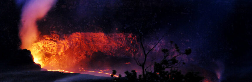
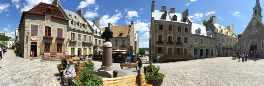
1800’s, this chain of hotels were on major stops on the rail tracks to the western coastline. This specific hotel is one of the biggest landmarks of the city and can be seen from afar as it is situated on a hill next to the Saint Laurant river. It is where arguably the most historic meeting of World War II between Winston Churchill and Franklin D. Roosevelt was held in 1944.
    2. La Citadelle de Quebec: Also called the Citadel, it housed the active military regimen of the monarch of Canada and the Governor General. With stunning views of the city and historic landmarks, a walk along the two city gates is a must for the history enthusiasts and casual tourists alike.
    3. Plains of Abraham: This is where the historic seven years’ battle between the French and the British army and navy took place in 1700’s.
    4. Hotel du Parlement: The current parliament house houses major artifacts from the 400 year history. The free 30 minute tour is a worthwhile investment to learn about the intricate details of the history of the city.
    5. Musee de la Civilization: After taking in all the history you can find in the city, top off with the well articulated displays in the museum to relate the historical events that built the city. Starting from the French invasion to replace the aboriginals in 1500’s to the modern establishment of the Quebec City in 1869, the visitor will be well versed with the city history.
    6. Battlefields Park and fortifications: Fortifications and canons everywhere in the city sings the songs of the numerous battles fought here. A walk along the edges of the upper town while dwelling on imaginary war visuals boggled my mind.
    7. Old Town: Winding alleys of old town, exquisite local artwork, and cobblestones streets d84fc-img_0099are going to make you believe that you are in the other side of Atlantic. Be sure to click pictures, but do not forget to experience the charm of the area by visiting local shops and sink in the culture.

Food Scene and Nightlife:
No points for guessing how rich offerings in terms of restaurants a classic French town would have. Being the foodies we are, we managed to find some of the exquisite food options in town for all meals. Here are some key places we tried out and were mesmerized by each:
1. Chez Boulay – bistro Boreal: Has to be one of the best Nordic meals we have had. Confit Goose and Duck, and the Arctic Char were amazing. Be sure to get a reservation or get in before 7pm to avoid wait. Check Yelp reviews here.
2. Cochon Dingue – French breakfast/brunch place in lower town near the Ferry terminal. We had the french toast, and Salmon Confit benedict from the Dejeuner menu and enjoyed every bite of them. Yelp has reviews and recommendations for your aid, but if you can afford to spend some time to have brunch or breakfast check it out.

We are always up for exploring local pubs and bars to feel the local culture and experience the nightlife. So we walked a mile away from the touristy places and found a nice Karaoke bar in the city center. La Ninaksi du Faubourg did have a fantastic atmosphere with locals coming in and singing away. Beer list was exhaustive with local breweries featured in the draft. We enjoyed some melodious French songs and sang along while sipping some old school Canadian Whiskey. I am still humming some of the songs I learned there, and do recommend paying a visit if you are in town.

Accommodation:
We ended up staying in Levis, QC on the other side of the river. It is an easy ferry ride from the Quebec City ferry terminal and it costs about CAD 14 round trip for two. Our hotel in Levis – Four Points Sheraton was located close to the Levis ferry terminal too, and had ample parking space and upgraded interiors.

Additional Tips and Info:
Wi-fi: Every tourist’s worst nightmare these days is lack of data in their smartphones. QC definitely solves the problem, and along with other amenities displays how welcoming the city is to tourists. Every pub, restaurant has free wi-fi, and on the streets one can get into the city wi-fi network easily.
Restrooms: Many clean and safe public restrooms are located in the nooks and crannies of the city.
Language: It helps if you parlez Francais but no one frowned at us if we said je ne pas parle Francais. We were astonished by the locals’ ability to switch between French and English so swiftly and needless to say how courteous people are in this city.
Driving: Everyone drives in the right lane, and moves to the left lane only for passing. To an American driver, it is a sight from another planet. What a place!


Gallery:


View of Saint-Laurant river from Upper Town

Chateau du Frontiac lit up in the evening

FDR statue in front of La Citadelle

Chateau du Frontiac stands tall

Old Town – Rue du Petit Champlain

City artwork in lower town

Rue Cul De Sac

Local Artwork

General Post Office

Cobblestone Chemins in old town

Hotel du Parlement

Old Town

Fontaine de Tourney

Summer evening in Lower Town

View from Battlefields Park

Fairmont Le Chateau du Frontiac