
Hawaii Volcanoes National Park
One of the UNESCO World Heritage Sites, covering over 500 sq. miles of land covered with rock formations and fresh lava flow, Hawaii Volcanoes National Park is a heaven for Geologists. The Mauna Loa and Kilauea volcanoes are the two shining stars in this park that is criss-crossed with trails and paved roads. After entering the park, follow an offline map, or use one of the Driving Tour Smartphone Apps (e.g. Shaka Guide).
For the list of places to cover, refer to Tripadvisor or any public sites including the NPS portal (Click here for a detailed offline printable map).
We thought sharing a little bit of knowledge about Volcanoes and the park might be helpful in your next visit to the park in relating to the concepts much easily. If you are interested in learning about Volcanoes and the formation of Earth, read on.
Written by our resident Geologist co-author, Rupsa
Hawaii Volcanoes: The history and science behind it
All the Hawaiian Islands and Emperor seamount chains are part of a mantle plume system. Mantle plumes or hotspots are nothing but molten rocks (lava) that rise from deep in the earth (mostly mantle) and reaches the surface of the earth through a weak zone (could be some deep fractures). The other common examples of islands created by hotspots are Iceland, Galapagos, etc.
Mantle plumes are stationary and can erupt through hundreds of years to millions of years before going extinct. Hawaiian plume has been erupting for millions of years creating Emperor Seamount chains, followed by Kauai which is the oldest island in Hawaii. As the Pacific plate moved over the plume, it went on to create Oahu, Maui, and the rest of the Hawaiian Islands before creating the Big Island. The hotspot is under Big Island currently. As the rate of plate motion has slowed down over the years, the same part of the plate is over the hotspot for a longer period, creating the largest island in Hawaii.
There are three types of lava flow structures that are most abundant in volcanic islands like Hawaii.
- Pillow lavas: Pillow lavas are volumetrically the most abundant type commonly found in the underwater seamounts.
- Pahoehoe lava: If lava cools slowly and does not move too fast it forms smooth ropy lava called pahoehoe. This type of flow forms some of the common features on the surface. Pahoehoe lava is characterized by a smooth, billowy, or ropy surface.Pahoehoe flows tend to be relatively thin, from a few inches to a few feet thick.
- A’a lava:If lava cools quickly and moves fast it can tear into pieces called A’a. A’a flow is characterized by a rough, jagged, spinose, and generally crackly surface. A’a lava flows tend to be relatively thick compared to pahoehoe flows. A’a flows, while rocky and sharp on the top, are extremely dense underneath – producing some of the most difficult rocks to cut through. Several hikes in the National Park take you past huge boulders of dense solid A’a. It is easy to compare with Pahoehoe that tends to be in layers.
Pele’s hair and Pele’s tear: Named after the Hawaiian goddess of fire, Pele, these structures form during times of high fire-fountaining. Pele’s hair are thin filaments of stretched out basaltic glass. Pele’s tears or Achneliths are tiny droplets of lava that look like tear-drops.

Sulphur Springs abundant with Pele’s hair and tears
Researchers have found that these are formed by the same overall process from the lava fountains, depending on the velocity of the erupting lava. High velocity and strong winds favor formation of Pele’s hair. Sometimes Pele’s tears are found attached at the tips of Pele’s hairs.
Big island has multiple volcanoes both active and dormant. Three major ones are –
- Mauna Kea – Dormant Cinder Top Volcano, 4,205m tall. Has a steep and irregular topography compared to other similar volcanoes in the area.
- Mauna Loa – Another cinder top volcano at 4,170m tall, it is younger than Mauna Kea, and erupts every few years. A series of earthquakes beneath Mauna Kea may signal that an eruption could occur within a short time, although it cannot predict the magnitude of eruption.
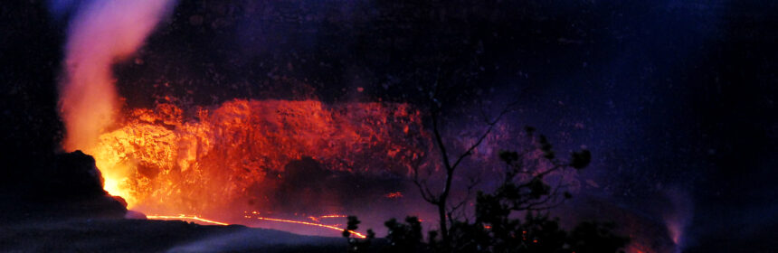
- Kilauea – In the last few years, Kilauea volcano is active and erupting continuously. Before going to Hawaii, do check the current lava flow status here. The recent eruptions are from the Halema’uma’u Crater at its summit and from the Puʻu ʻŌʻō vent in towards the east. Lava flow from Puʻu ʻŌʻō is relatively recent (30 years old) and continues to enter the ocean at Kamokuna. Although surface flows have been common in this eruption, most of the lava from the vent travels concealed in lava

Kilauea Crater from Jagger Museum (shot around 5am)
tubes until it reaches the ocean. A blowout during a 2008 eruption built a lava lake in Halema’uma’u crater, which is a remnant of a past explosion. The lava is in this crater is as light as water. The base level of the crater is unstable to the point that it rises and falls by the minute. The gaping hole through which the eruption is visible, is a direct conduit into Kilauea’s magma reserves. This crater is just a gentle reminder how active and dynamic our mother Earth really is.
The experience of witnessing rock in its bright molten state and watching new land being formed is quite a fascinating experience, if you are lucky enough to witness it. When hot lava enters the water, it bursts into pieces, building new land at the ocean edge from the fragmental material. This pile of rubble is then covered with a veneer of lava flows, forming a “bench”. Initially the bench is weak enough that it can collapse with the smallest disturbance around it. After multiple layers of such deposits and cooling of magma, typically taking several hundred years, once the bench is stable and large enough, a new island is created. After hundreds of years of depositions of lava followed by some tectonic activity (earthquake mostly) those submerged islands rose above the water and resulted in the islands the way we see them in the present. In a nutshell, that is a brief history of the Hawaiian Islands. There are multiple islands like these that are currently submerged under the ocean in the area, and in a few hundred years we will be able to see another island full of volcanic activity, south of the Big Island.
Tips Before Visiting the Park
Although there are clearly marked barriers and signs at sites, there are some common sense warnings that one MUST follow. Read on to find out the science and geology behind those hazards and why it is important to follow them for your own safety.
- What are the Volcanic Hazards Facing you?
- Bench collapse can cause a 100-200 feet steep drop into unknown craters
- Rock jets & littoral fountains hurl hot lava that erratically gets sprayed
- Steam blasts toss rocks
- Acid fumes (Sulphur di oxide, carbon monoxide) and glass particles can irritate eyes and lungs causing suffocation and choking
- Scalding waves burn where lava meets ocean
- Recommendations:
- Do not stand near the steep cliffs. This land is extremely weak and breaks off frequently; it is impossible to climb up from the crater or ocean vertically.
- Do not go on the rocks close to a volcanic eruption. Bench collapses have killed people.
- Do not go near the water as it can be boiling hot and likely contains sulphur fumes.
- Move inland quickly if you hear unusual noises.
- Please be prepared for personal hazards especially when hiking through the enormous lava fields:
- Most injuries are not directly due to the eruption. Intense sunlight and high temperatures can lead to dehydration, heat exhaustion, or sunstroke. Air temperatures near lava flows can exceed 120°F (49°C), depending on cloud cover and wind conditions.
- At higher elevations, wind and rain can lead to hypothermia (low body temperature). Carry sunscreen and a hat, and drink more water than you think you need.
- Injuries from a fall are common. It is easy to break through a thin, overhanging crust of lava or trip on a crack and fall on the abrasive, glassy surface. U.S. Geological Survey (USGS) scientists always wear long pants, sturdy boots, and sometimes gloves when working near the flows. Never shorts and flip-flops!
- Before visiting the lava field, check with Park Rangers for current conditions and for the best approach route. Park Rangers do not recommend that you attempt the hike to the coast if you are unprepared or uninformed. The area is remote, has no shade or water source, and is seldom patrolled. Also, most areas in the park has no cellphone reception.
If you are interested to find out more about Hawaiian Volcanoes there are plethora of information in the internet. Some of the sites that I personally like are:
- USGS website in general. Their live webcam of Kilauea is quite fascinating.
- Universities often organize field trips to the Hawaiian Volcanoes and their reports are usually easy to follow and contains lots of authentic interesting information. One of such link is here
Because of their altitude, the summits are covered in snow in winter and are usually cold and windy in the rest of the year. So, if you plan to go for star gazing, sunset viewing at the summit, or hiking up to the visitors’ center (beyond which tourists are not allowed to drive on their own) please be prepared with warm clothes unless you are used to the Polar weather!! If you go for star gazing and sunset viewing (highly recommended) with a tour company (read our experience), they usually provide parkas. However, if you are like me to whom anything below 55˚F (10˚C) is freezing please carry a pair of gloves, and wear long pants (preferably wind buster), and close toed comfort shoes are also highly recommended.